 Understanding GPS and network location
Most Android devices can provide your current location from either the network (cellular or WiFi) or a built-in GPS. Radar Alive! can use either of these sources.
Radar Alive! uses location data to:
- Show your location on the map
- Show the range and bearing from you to any point you tap on the map
- Center the map on your position when you tap the position button.
Considerations about location sources:
- GPS:
- is very accurate
- may consume significant battery power
- may not work indoors
- Network location data:
- is less accurate than GPS, and in rural areas may be very inexact
- consumes negligible battery power
- works any place there is a cellular signal
Using Location Data
The location button on the bottom right of the screen shows location status:
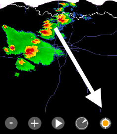
The location button changes color to show location status:
 indicates a good fix (<1000 ft, <4 minutes old)
 indicates a recent fix with poor accuracy
  indicates a stale fix (>4 minutes old)